
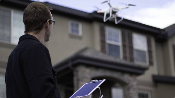
The drone market is exploding. IHS research predicts the professional drone market will maintain a compound annual growth rate of 77.1 percent through 2020. This is primarily driven by agriculture, energy, construction, and yes, insurance. Companies like State Farm, as well as Travelers, have already deployed drones in the insurance claims process for gathering imagery and keeping their teams safe. But as large and mid-tier carriers assess advantages like these, many are left with a question: should we fly a manual drone or find an automated drone solution?
Let’s take a look at the pros and cons of a manual solution compared to what an automated solution like IMGING can provide for carriers.
Why Some Carriers Use Manual Flight
Safety
According to the World Health Organization, falls are the second leading global cause of accidental death. No carrier wants to put their adjusters in harm’s way. A fall from a roof can cause injuries, end careers, and result in fatalities. The less time adjusters spend on roofs, the safer they are, which makes drones an obvious win for adjuster safety.
Low Initial Investment
First, an off-the-shelf drone is usually relatively inexpensive. With some drone solutions costing upwards of $40K a year, it’s easy to see why a $1,500 drone seems like a good option. Still, not all carriers realize what they might be missing. A drone platform offers many features essential to a claim workflow. Plus, there are options that blend some of the affordability of an off-the-shelf drone with premium functionality. From the right vendor, $40K can get you several drones—not just one—and an incredible array of features that make a drone an essential part of a workflow (we’ll get to this in a moment).
Better Imagery for Skilled Pilots
In general, a manual flight solution is a great way to gather imagery. An experienced pilot can maneuver a drone close to structures, snap damage photos, and in many cases, thoroughly document a property. The problem is that the average adjuster may have neither time nor the desire to learn a new skill like manual flight. Certainly, manual drones are great tools for an adjuster because they get new ways to gather data—but only if they have the chops to do it.
More Imagery But More Headaches
While drones help adjusters gather lots of imagery, an off-the-shelf drone doesn’t help an adjuster keep images organized. The moment a flight is over, the adjuster must fumble with an SD card and upload a random array of photos to a folder. When it’s time to review them, she may struggle to remember where on a property the photos were taken. If another team member needs to use this imagery, he won’t have any reference either.
Yes, manual drones are a step in the right direction, but there’s so much more to the story.
The Case for a Drone Platform—Digitizing vs. Photo-Gathering
An automated drone platform doesn’t just take photos. It redefines the way carriers can process claims by automating portions of the workflow, ensuring consistency, and making imagery easy to access, reference, and share in a collaborative way. Manual flight provides safety and imagery, but that’s where it stops. To get more from a drone, you need a platform built to take the process to the next level and it all starts with how adjusters gather data in the field.
Fleet and Team Management
Through fleet and team management features, the right enterprise software platform can provide insights into your workforce previously unimaginable. Fleet and drone management will help you understand exactly where and when inspections are happening, their current state, and even how many hours each drone has spent flying.
Flight Planning for More Consistency
An automated drone solution uses a flight plan to gather data rather than manual input. Because of these flight patterns, platforms like IMGING can get 100 percent roof coverage at incredible levels of detail. Imagine if every inspection was the same incredible quality—automated flights let you do it. Drones don’t get tired, they don’t have bad days, and they can gather the same data every single time they fly.
And here’s the kicker. You can still fly manually to add extra photos if you want. With platforms like IMGING, you’re not locked into a fully automated autonomous flight plan. You can take over whenever you want to investigate something more closely. IMGING blends all the benefits of manual flight with the consistency of automated flight plans.
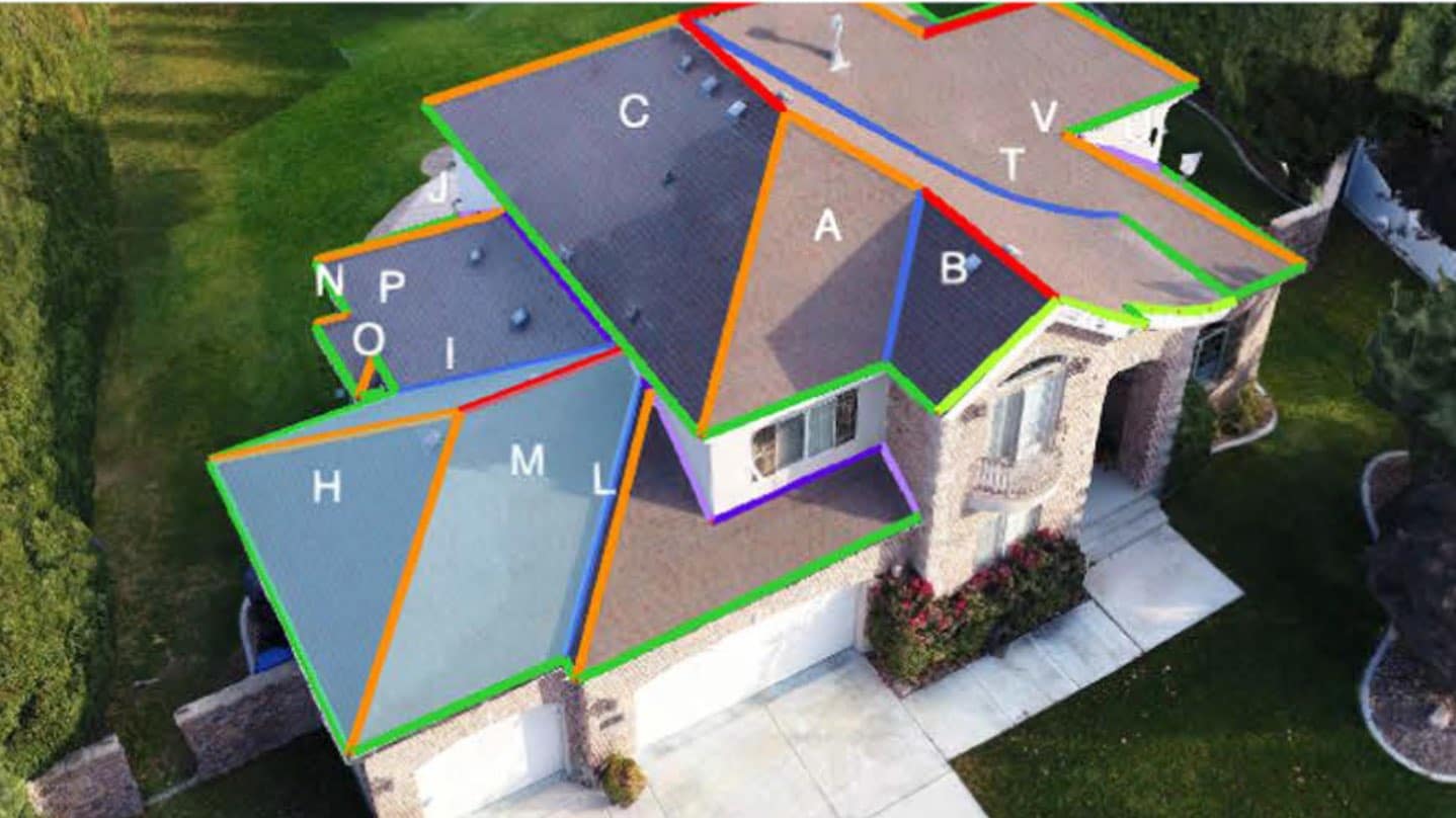
Fully Digitized Properties
Flight patterns are great for gathering static imagery, but it’s our unique flight plans that allow us to gather the imagery we need to give you photo-realistic 3D models. Imagine if instead of viewing static images, you could explore and measure a full digital representation of the property on your desktop from anywhere. This makes it so adjusting teams can visit a property without actually being there.
Better Collaboration
Rather than juggling SD cards, uploading images, sharing files, and creating a mess for your organization, an automated drone platform lets you store, share, and access all data captured on-site through a single app. Images are uploaded to a cloud-based app wirelessly and anyone can access the data they need. Plus, all of the images are GPS-tagged, so it’s easy to see where on a property an image was captured. This means that no matter who gathers the data (an adjuster, a pilot-for-hire, etc.), the person reviewing it knows exactly where the photo was taken in relation to the rest of the property. This can help create consistency and help adjusters avoid potential errors.
Scalability and Flexibility
As noted, an adjuster can learn manual flight, but it takes time to become an expert. Automated flights, however, make it easy for anyone with the proper certification to gather the necessary claim data. This means it’s much more feasible to scale a drone solution across a team of adjusters, or to outsource drone-based inspections. Instead of using your adjusters to gather data in the field, you can have them focus on reviewing claims as part of a desk adjusting model and use a service like IMGING On Demand to provide you with the data you need. This creates more flexibility in terms of where you position drones, how you scale operations for CAT, and how you manage shifts in claim demand across entire territories.
Augmented Decision-Making With AI
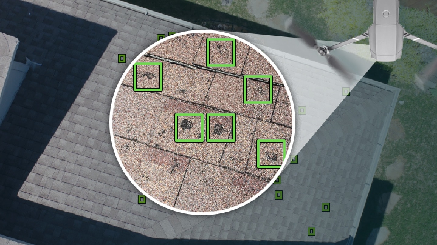
One odd issue with using drones for insurance claims is that because they gather such an immense amount of information, it can be difficult to sort through it all. With a drone platform like IMGING, built-in artificial intelligence can make the process much simpler. AI can automatically identify things like hail (see image), rust, missing shingles, and other forms of damage. This points adjusters to areas of interest automatically, which can save adjusters hours compared to manually reviewing images for damage. Inside the app, adjusters can review suspected damage and confirm or deny it and add notes about what they’re seeing. All this info gets automatically added to shareable reports.
Data Export Options
Manual flight improves image quality, but it’s still part of a traditional adjusting process. Instead of just uploading photos, platforms like IMGING make it easy to add a drone into your claim workflow. Images are neatly organized inside of jobs in the app. Measurements, 3D models, and AI damage detection allow you analyze information quicker than ever. When it’s time to create a full estimate, adjusters can export data or file formats that plug directly into estimating software they already use. This gives them powerful ways to gather, organize, and analyze imagery, all helping them get to accurate settlements faster.
Final Thoughts
Manual drones aren’t much more than flying cameras and they require a decent amount of skill to pilot successfully. While they certainly offer advantages over traditional inspections (safety, image quality, and so on), they’re often boot-strapped into a carrier’s workflow. The future is bigger. For carriers to see the benefits of drones at scale, they must re-think their relationship with data and carefully consider how technology fits in their existing tech stack.

It’s not about new ways to get photos, it’s about rearchitecting insurance altogether. With a sophisticated drone solution, adjusters can improve claims by condensing cycle times. Underwriters can understand risks in ways that would have been unimaginable just a few years ago. Carriers can leverage vast quantities of data to understand important trends and create data-driven standard operating procedures that enhance the customer experience from top to bottom. All told, platforms like IMGING give carriers get ways to address shifts in claim demand, analyze risk, and lower loss adjustment expense all at the same time.


